On Lone Cone - Hiking the Lone Cone trail in Tofino
by Malcolm Johnson, Tofino
![]() Lone Cone is a constant presence in Tofino, even for those who have
never climbed it. At 730 metres, it is in the middle of the triad of
peaks– Catface, Lone Cone, and Colnett–that run from northwest
to southeast through Clayoquot Sound. Anyone who has lived here for
any length of time has seen its triangular mass in all its aspects
- shrouded in cloud, lit up orange by sunset, dusted by snow, or simply
bare and green against blue sky. From Tofino, but especially from the
water at its base, its symmetry and sheer size are remarkable. Lone
Cone, besides being one of the most appropriately named mountains anywhere,
has a certain feel to it. It does everything that a mountain is supposed
to do; it just sits there, like a huge chunk of ancient volcanic rock,
which, incidentally, it is. And the humans sit at its base, and wonder.
Lone Cone is a constant presence in Tofino, even for those who have
never climbed it. At 730 metres, it is in the middle of the triad of
peaks– Catface, Lone Cone, and Colnett–that run from northwest
to southeast through Clayoquot Sound. Anyone who has lived here for
any length of time has seen its triangular mass in all its aspects
- shrouded in cloud, lit up orange by sunset, dusted by snow, or simply
bare and green against blue sky. From Tofino, but especially from the
water at its base, its symmetry and sheer size are remarkable. Lone
Cone, besides being one of the most appropriately named mountains anywhere,
has a certain feel to it. It does everything that a mountain is supposed
to do; it just sits there, like a huge chunk of ancient volcanic rock,
which, incidentally, it is. And the humans sit at its base, and wonder.
The Approach
The approach to Lone Cone is more complex, and more interesting, than most hikes one will encounter on Vancouver Island. It requires a boat trip across the tidal flats of Tofino harbour, past Opitsaht, and around the corner to the dock at Kakawis on Meares Island. From there, it is a dirt road to the residences of the Family Development Centre, and then through a muddy clearing where an old truck is slowly being consumed by rust and forest. You will cross a destroyed wire fence that was perhaps, at one time, intended to restrain the feral cattle that inhabit the island, and it is here where you enter the forest, and where the trail begins. Built in the 1980's by a crew led by Vernon Bruhwiler, it is a leg-burning, lung-sucking slog of a trail that equals Vancouver's Grouse Grind or the Chief Trail in Squamish for physical misery, and easily surpasses both of them for physical beauty. But note that this is full-on wilderness, and not an area to be taken lightly. if you come, be prepared to spend a night if things go wrong, and bring something to deter the wolves. It should also be noted that the property through which the trail passes is not public access, and that permission must be sought to hike it.
The Flats
The flats are only the beginning. This section of the trail is classic West Coast temperate jungle, a winding route through impossibly lush greens with plenty of mud underfoot. In winter the forest here is dripping wet, closed in by salal, and strewn by windfalls. You will realize in short order that this is not the tourist path of the national park. But it is gorgeous through here, and you can push the pace; you will pass several old cedars, and a freshwater creek where you should pause to fill your bottles. This water tastes better than most five-dollar gourmet bottled waters, and your body will definitely need the fluid on the way up. I know this well, because on my first time up, I thought I was going to fall over and die of dehydration.
The Ascent
If you look at a map of Lone Cone, you will notice that the contour lines of the mountain are densely packed, much like a series of wobbly circles drawn by a small child, or the rings of a cut tree. Those tight lines mean that it goes up fast, and they mean that this hike will kick your ass. From the end of the flats, it is a constant ascent up and across the huge slope. At times it reaches a pitch that requires scrambling with your hands, and it just keeps going up and up as far as you can see. It's deceptive; you get teased by glimpses of sky up ahead, but trust me, you're nowhere near there yet. It's like climbing a Stairmaster, except harder, and the soft soil shifts under your feet; you will be pouring sweat, your legs will be screaming against the lactic acid build-up, and you will be sorely tempted to give up and quit. But you have to remember that the view is worth the drudgery, even though you will start to feel like those high-altitude mountaineers who take one step, and then rest for ten seconds, and then step again. Jeremy Koreski and Francis Bruhwiler once climbed it in 51 minutes, which is a heavy accomplishment. There are many hikes that have greater vertical gain, but Lone Cone is unrelenting.
The Prospect
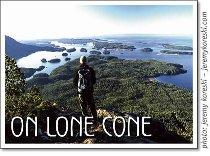
The view from Lone Cone is, as the kids say these days, sick. In fact, it is beyond that; it is revelatory. Although you get brief glimpses of water through the trees on the ascent, the wide-open prospect comes all of a sudden. And it will blow your mind. Suddenly everything is open before you; the coastline from Wreck Bay all the way north to Flores; the entirety of the Esowista Peninsula; the town of Tofino far below; Stubbs and Wickaninnish and Vargas and the rock reefs offshore; the ragged, glaciated peaks of the Vancouver Island ranges behind. From this height the sheer scale of the Pacific becomes apparent; the land is dwarfed by it, and the horizon seems to be a hundred miles away. There is a real sense that this is the end of the Earth, and that this would be the best place to be when the Big One hits and the tsunamis sweep the ocean beaches. One cautionary note: this place is not recommended for sufferers of vertigo; the drop-off is sudden, and the flatlands of Meares are a long, long way down. Tread carefully, because a slip here could be bad news indeed. But the lookout is amazing, and is probably the best sunset spot in Canada. Linger here. You'll know when you get here that the hike was worth it.
The Descent
If your legs are still holding out, the descent is best experienced at a pace somewhere between full run and freefall. Be careful to follow the trail ribbons; it would be all too easy, especially in twilight, to charge downhill into a draw, only to find yourself lost and unable to relocate the trail. But go fast and faster on the way down, because it's more fun that way; you can use the smaller trees and bushes at the sides of the trail as brakes, and if you don't wipe out a few times, you're not going fast enough. Your quadriceps, already drained by the hike up, will turn to jelly, and your bones will jar, but the downhill is the pure fun. And going out-of-control on a trail descent is one of the only activities that brings the same rush as surfing - that stoked feeling of going super fast, but knowing that if you fall you're worked, dude, worked.
The Exit
Ideally, you will come back through the flats in deep twilight, with the moon rising and your eyes straining to see the trail. The gnarled trees and ferns give the forest a haunted look, like where dark wizards congregate in fantasy films. You will emerge again at Kakawis, and walk back to the dock with the mountain looming beside you. On the way back across the water, with the orange lights of Opitsaht to port, you can think about well-earned dinner and celebratory beverages. And you can reflect on the fact that despite the insubstantiality of all the New Age connecting-with-the-earth stuff, there certainly is something about being on a massive dormant cinder cone amidst giant ancient trees; it is, without a doubt, good for the soul.
Malcom Johnson, a recent graduate of the University of Victoria, is a writer who lives in Tofino. You can email him at malcolmjohnson@coastalbc.com
Pacific Rim National Park
- Radar Hill
- Schooner Cove Trail
- Shorepine Bog Trail
- South Beach Trail
- Nuu Cha Nulth Trail
- Rainforest Trail
Tofino Hiking & Trails
Tofino Time Magazine February 2003
- New Community Hall in Tofino
- Oysters in Clayoquot Sound
- Comic: The Cheese Club
- Events in Tofino
- Surfgear for Beginners
- Tofino golf: Get a Better Grip
- Tofino hiking: On Lone Cone
- Art & Science of Facials
- Red Door - No More
- Steaming Hot Tofino Winters
- Treating the Winter Blues
- Tofino artist Keith Plumley
- Tofino art: Penny Birnam
- Community Directory
tofino | tofino time | activities | accommodation | events | directory
maps | travel | food | art & artists | photos | horoscope | tides
search | magazine | issues | articles | advertising | contact us
hosted in tofino by tofino.net & studio tofino
© 2002-2014 copyright Tofino Time Magazine in Tofino Canada
Tofino hiking: On Lone Cone - Hiking the Lone Cone trail on Meares Island, north of Tofino, BC, Canada.


quick links:
- tofino accomodations
- tofino calendar
- tofino surf report
- tofino horoscope
- march horoscope
- tofino map
- tofino fishing report
- tofino tides
- tofino weddings
tofino events:
- tofino concerts
- tofino events
- tofino movies
- tofino festivals
- tofino yoga classes
- tofino whale festival
tofino time magazine:
- tofino time march 2016
- tofino event listings march 2016
- tofino concerts in march 2016
- tofino movies in march 2016
- cox bay | wickaninnish beach
- chesterman beach
- tonquin beach
- tofino brewing co.
- tofino wedding guide
tofino accommodation:
- tofino cabin
- tofino camping
- bed & breakfasts in Tofino
- tofino hostels
- tofino motels
- tofino hotels
- tofino vacation rentals
- petfriendly accommodation
activities:
- tofino bike rentals
- tofino bear watching
- tofino bird watching
- tofino boat charters & cruises
- tofino fishing
- hot springs cove
- sea kayaking in tofino
- tofino storm watching
- tofino surfing
- tofino whale watching
- tofino yoga
shopping:
services:
- tofino yoga, spa & wellness
- tofino restaurants
- tofino internet cafes
- tofino travel & transportation
- tofino real estate
- tofino taxi services
- tofino wedding & events